Freight News:
The World’s Most Remote Airports

There are few places on the planet to which man has not flown to within an aircraft. Even Antarctica is home to dozens of landing strips, though there are no developed public-access airports that you can fly into.
So, which are the most remote publicly accessible airports in the world? We team up with CAV Systems, specialists in aircraft anti-icing systems, looks at some of the airports in secluded parts of the globe. They have also included the coordinates for the adventurous travellers looking to explore these locations.
Mataveri International Airport
Location: Easter Island
Coordinates: 27.1587° S, 109.4300° W
Elevation: 69m
Located in Hanga Roa, this is the world’s most remote airfield. The next closest airport is in Santiago, Chile, almost 2,400 miles away. The airport sees more than 100,000 passengers per year, but it is easier to reach and avoid crowds by private plane.
This airport is so secluded, there is only one known airline route that travels to it. LATAM Airlines runs a few flights daily from Santiago to the airport.
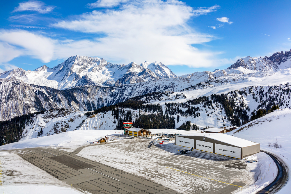
Courchevel Altiport
Country: France
Coordinates: 45.3959° N, 6.6344° E
Elevation: 2,008m
This is Europe’s highest airport and a key travel destination for hundreds of thousands of skiers every winter. On top of its high-altitude location, the Altiport also has the world’s shortest runway at 537 metres long. This means that only small, personal aircrafts can be safely chartered onto it. If you are an avid skier and owner of a private aircraft, there is no better way to lean into that truly exclusive VIP feeling.
Svalbard Airport
Country: Norway
Coordinates: 78.2469° N, 15.4933° E
Elevation: 28m
Calling Svalbard remote is an understatement. It Exists as the northernmost airport with public flights available and there is no regular boat service to Svalbard at any time of year. The only way to arrive by ship is as part of an expedition cruise.
That means if you have a Northern Norway adventure in your vacation plans, it’s best to charter a private flight. This archipelago enables visitors to see the northern lights in the winter, and the summer brings its 24 hours of “midnight sun,” offering even more time to see polar bears, Arctic foxes, and Svalbard reindeer.
Paro Airport
Country: Bhutan
Coordinates: 27.4052° N, 89.4210° E
Elevation: 2,244m
Paro Airport is the only international airport in Bhutan, which can only be reached while it is light outside. This remote airport is situated in a valley surrounded by the Himalayas and is close to the Paro Chhu River. The high-altitude approach that is taken to land at Paro Airport results in a thrilling arrival. Anyone traveling to Bhutan can enjoy breathtaking trekking and visit gorgeous monasteries built right into the cliffs of the mountains.
Cordova Airport
Country: Alaska
Coordinates: 6.1714° N, 75.4277° W
Elevation: 4m
The short runway at this airport is typically used by small planes and seaplanes. If you are traveling to the Cordova area of Alaska, you won’t be able to drive, as Cordova is not accessible by roads due to not being part of the road system. The best way to visit Cordova is to charter a private flight and fly directly to Cordova Airport.
While airports and travelling can be frustrating, having an insight into some of the more difficult locations to land can add a level of perspective to help plan your journey. So, if you find yourself on a commercial airline the next time you’re travelling and your trip is not going according to plan, just be grateful you are not having to fly into an airport miles away from your actual destination.